This site uses affiliates. Thank you for buying through our links and supporting this blog.


Ben Lomond Track Queenstown: Complete Hiking Guide (2026)

The Ben Lomond Track looks almost suspiciously convenient. It begins in central Queenstown, climbs directly behind the Skyline Gondola and delivers the kind of huge alpine panorama you would normally expect after driving several hours into the backcountry.
That convenience is also what catches people out. Ben Lomond is not a casual extension of a morning at the gondola. The full track from Queenstown covers 14 kilometres (8.7 miles), gains 1,438 metres (4,718 feet) and takes around six to eight hours. The final climb beyond Ben Lomond Saddle is steep, exposed and noticeably rougher than the lower track.
This guide explains the full Ben Lomond Track, the shorter saddle hike, every practical starting option, when the gondola is worth paying for, where to stay, what to pack and when turning around is the smart decision.
It is based on our original experience, with practical and safety details checked against current Department of Conservation guidance.

In a hurry?
Book these Queenstown essentials first
You do not need a tour to hike Ben Lomond, but these bookings make the hike and the rest of your Queenstown stay considerably easier.
Shorten the hike:
Skyline Gondola round-trip ticket
Stay near the trailhead:
The Dairy Private Hotel
Best post-hike recovery:
Original Onsen private hot pool
Lake Whakatipu floating sauna
Book for another day:
Milford Sound day tour and cruise
Glenorchy and Paradise half-day tour
Ben Lomond Track Quick Facts
| Route | Distance | Time | Elevation | Best for |
|---|---|---|---|---|
| Tiki Trail to summit | 14 km (8.7 mi) return | 6–8 hours | 1,438 m (4,718 ft) gain; summit at 1,748 m (5,735 ft) | Fit, experienced hikers with a full day and suitable conditions |
| Gondola to summit | Approximately 11 km (6.8 mi) return | Approximately 4–6 hours | Roughly 1,000 m (3,281 ft) gain | Summit hikers who want to save their legs for the alpine section |
| Tiki Trail to saddle | 10 km (6.2 mi) return | Around 5 hours | Saddle at 1,326 m (4,350 ft) | A shorter but still demanding hike from town |
| Gondola to saddle | 7 km (4.3 mi) return | 3–4 hours | About 550 m (1,805 ft) net climb | The best shorter option and the sensible turnaround in marginal conditions |
Difficulty: Demanding, steep and rated as requiring high fitness by DOC. The formed track becomes rougher and unmaintained beyond the saddle.
Normal hiking season: Usually summer into early autumn, but conditions matter more than the calendar. Snow and ice can remain well outside winter.
Facilities: Toilets, food and water are available at the Skyline complex. A basic toilet sits approximately 100 metres (328 feet) before the saddle, but it has no water, sanitizer or toilet paper. There is no drinking water beyond Skyline.
Cost: The hike is free. You only pay if you take the gondola, park in a paid car park or book a guide.
Official planning links: Check the current DOC track page, NIWA summit forecast and official Ben Lomond map shortly before leaving.

Where to Stay for the Ben Lomond Track
Stay in Downtown Queenstown, preferably near Brecon Street, if Ben Lomond is a priority. You can walk to the Tiki Trail or gondola before breakfast traffic starts and avoid wasting energy finding all-day parking.
The climb begins at the top of Brecon Street beside the Skyline base. This makes the northern side of Downtown particularly convenient, although anywhere in the compact centre remains walkable. I would not stay in Frankton, Fernhill or Arthur’s Point specifically for this hike unless you already have a car and other reasons to be there.

CLOSEST BOUTIQUE PICK
A characterful small hotel close to the gondola, with breakfast and sociable shared spaces. It is the easiest of these three for rolling out of bed and starting the Tiki Trail.

Queenstown Park Boutique Hotel
QUIET & WALKABLE
A polished boutique hotel beside parkland, around five minutes on foot from the centre. It gives you a quieter base while keeping Brecon Street and most central tour departures walkable.

COMPACT VALUE
A modern hotel with compact rooms just above the centre. Book it for the useful location and generally sharper pricing, not because you plan to spend the trip lounging in a huge room.
For more options and honest explanations of Queenstown’s hills, parking and transport trade-offs, read my complete guide to where to stay in Queenstown.

Should You Hike to Ben Lomond Saddle or the Summit?
The saddle is not a consolation prize. It sits at 1,326 metres (4,350 feet), already gives you broad views over Lake Whakatipu and saves you from the steepest, roughest and most exposed part of the route.
Continue to the 1,748-metre (5,735-foot) summit only if the weather is stable, the route is clear of snow and ice, your group still feels strong and you have enough daylight for the return. The summit is the halfway point, not the finish line. Tired knees still need to descend everything you just climbed.
| Choose the saddle when… | Continue to the summit when… |
|---|---|
| You want a substantial half-day hike from the gondola | You are comfortable with a full day and more than 1,000 metres of climbing from Skyline |
| Cloud is building around the summit | The summit remains clear and the forecast is stable |
| Snow, ice, strong wind or wet rock appears | The route is snow-free, dry and within your experience |
| Your legs already feel depleted | You still have plenty of energy for the climb and long descent |
| Daylight is becoming tight | You have a generous daylight buffer and a headtorch |
My recommendation: Plan for the summit, but treat the saddle as a valid destination. Deciding in advance that anything short of the top is failure is how people talk themselves past obvious turnaround signals.
Ben Lomond Track Starting Points
There are four ways to access the Ben Lomond Track. For most people, the real decision is between walking the Tiki Trail from Brecon Street and taking the Skyline Gondola.
1. Tiki Trail from Brecon Street
The Tiki Trail begins beside the Skyline Gondola base at the top of Brecon Street, behind the stone wall of Queenstown Cemetery. It is DOC’s preferred walking access and the most logical option if you want to complete the entire climb under your own power.
The trail gains roughly 450 metres (1,476 feet) over about 1.5 kilometres (0.9 miles). Allow around one to 1.5 hours to reach the Skyline complex. It is steep enough to take a meaningful bite out of your legs before the main alpine section begins.
2. Skyline Gondola
The gondola removes approximately 450 metres of climbing and saves around one hour in each direction. That is not cheating. It is a perfectly sensible way to spend more of your energy above the tree line, particularly if the summit is your priority.
Book the Skyline Gondola round-trip ticket here. Check the operating hours for your date and do not assume the first cabin runs early enough for your preferred start.
DOC also notes that you can buy a one-way ride down. Hiking up the Tiki Trail and taking the gondola down is useful if your knees dislike steep descents, but confirm same-day ticket availability and the last downhill departure before relying on it.
3. Skyline Access Road from Lomond Crescent
The Skyline Access Road begins on Lomond Crescent and eventually connects with the Tiki Trail. It is longer and less scenic, but its gravel-road gradient can feel less aggressive than the direct Tiki Trail.
This was the access used in the original field notes for this guide. The road itself is not particularly exciting; the useful part is avoiding the steepest initial switchbacks. Parking rules around residential streets can change, so check every sign rather than relying on an old promise of free all-day parking.
4. One Mile Creek Track
The One Mile Creek approach starts near the Fernhill roundabout. DOC explicitly flags this route as requiring navigation. It is not the best choice for a first attempt, an early start in darkness or anyone who simply wants the clearest line to the saddle.
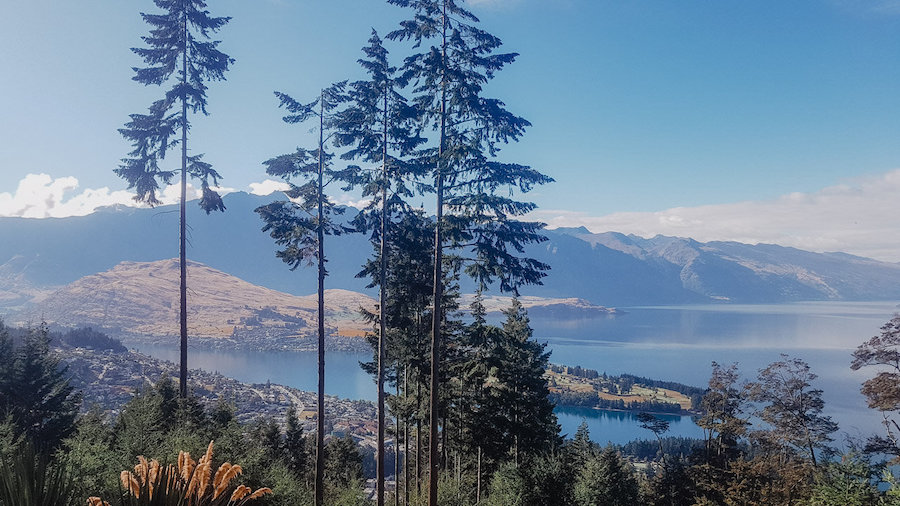
Where to Park for the Ben Lomond Track
The simplest plan is to leave your car at your accommodation and walk to Brecon Street. Central Queenstown parking is tight, and short time limits are useless for a six- to eight-hour hike.
Skyline now operates a 24-hour monitored car park beside the gondola and Tiki Trail entrance. Check its current rates and conditions directly before arriving. If you use street parking elsewhere, read the exact sign and make sure the space permits a full hiking day. Do not leave luggage visible in the vehicle.
You do not need a car for Ben Lomond. For the rest of a South Island road trip, compare Queenstown Airport suppliers using this rental-car comparison, then read my guide to renting a car in New Zealand before booking.

Best Time to Hike the Ben Lomond Track
Summer and early autumn usually provide the most straightforward hiking conditions, but there is no guaranteed snow-free date. Ben Lomond enters exposed alpine terrain, and the summit can collect snow in any season.
November through April is a reasonable planning window for ordinary hikers, subject to the actual forecast and track conditions. Start early during the warmest months because the upper route has almost no shade, afternoon weather can build and popular sections become busier.
Can You Hike Ben Lomond in Winter?
Ben Lomond in winter is an alpine undertaking, not the same summer walk with a prettier white hat. DOC states that alpine equipment is required in winter. Snow and ice make the steep section above the saddle considerably more dangerous, and avalanche conditions must be assessed.
If the route is snow-covered, you need the correct boots, crampons and ice axe plus the skills to use them. Microspikes are not a magic permission slip for avalanche terrain. Check the Queenstown avalanche forecast, local conditions and the Mountain Safety Council Ben Lomond guidance.
If you do not already have winter alpine experience, choose another walk. Queenstown Hill, the lower Tiki Trail and several lakefront tracks deliver good views without pretending enthusiasm is a substitute for mountaineering skills.
Read my Queenstown winter guide for safer seasonal alternatives and activities.
How to Check the Weather
- Check the NIWA Ben Lomond summit forecast, not only the forecast for Queenstown beside the lake.
- Review the current DOC track information.
- In snowy conditions, check the Queenstown avalanche advisory.
- Look at the mountain from town on the morning of the hike. A good forecast does not cancel what your eyes are telling you.
- Turn around if cloud closes in, wind becomes difficult, the surface turns icy or anyone in the group is no longer moving confidently.
Ben Lomond Track: Step-by-Step Route
These times are deliberately conservative and will vary with fitness, breaks, weather and whether you use the gondola.
| Suggested time | Plan |
|---|---|
| 7:00 AM | Start the Tiki Trail from Brecon Street in central Queenstown. |
| 8:00 AM | Pass the Skyline complex. Use the toilet, refill your water and continue towards Ben Lomond Saddle. |
| 9:30 AM | Reach Ben Lomond Saddle. Take a short break and check the weather before continuing. |
| 10:30 AM | Reach the summit. Enjoy the view, eat something and begin the descent. |
| 12:00 PM | Return to Ben Lomond Saddle and continue down towards Skyline. |
| 1:00 PM | Pass the Skyline complex and descend the Tiki Trail. |
| 2:00 PM | Finish the hike back at Brecon Street in Queenstown. |
Tiki Trail to the Skyline Complex
From Brecon Street, the Tiki Trail climbs steeply through Douglas fir and native beech forest towards Bob’s Peak. The shade is useful on a hot day, but the sustained gradient means you will start gaining elevation immediately.
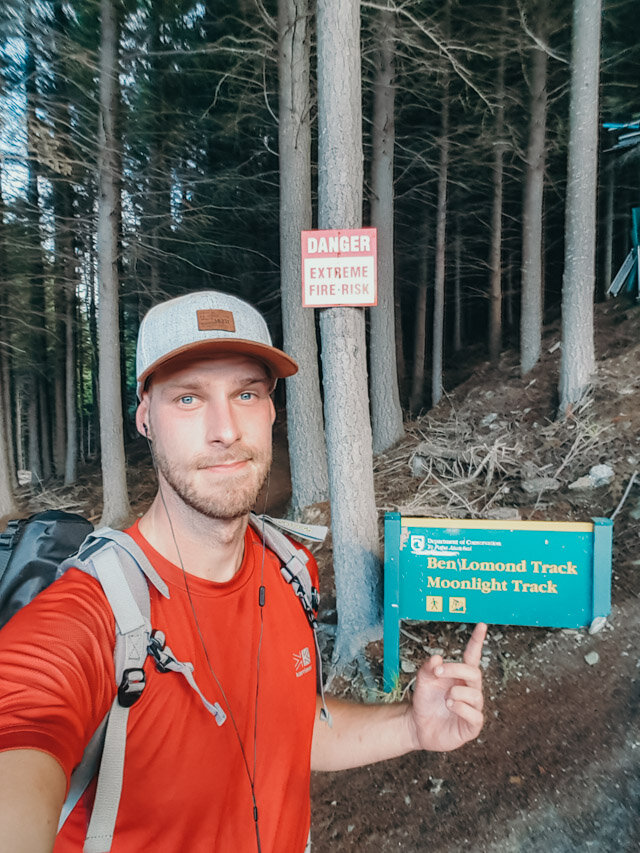
The reserve also contains a busy downhill mountain-bike park. Walking routes cross bike trails, and riders can arrive very quickly. Follow the orange markers, stop and look before crossing, and never use a bike trail as a shortcut.
One missed marker in the original hike behind this guide led onto a grade-six double-black bike trail and an unpleasant scramble past a four-metre (13-foot) feature labelled “Rollable as, bro.” Consider that a useful field test: the bike trails are not cheeky alternate paths. They are a terrible idea on foot.
Skyline Complex to Ben Lomond Saddle
From the Skyline complex, follow the marked walkway past the luge area and into the forest. The route briefly loses a little elevation before leaving the trees and entering open tussock country. Enjoy that tiny downhill section. It is not representative of what comes next.
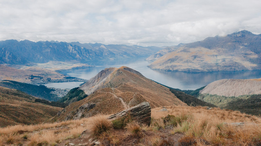
Once above the tree line, the views open across Queenstown, Lake Whakatipu and Kawarau/The Remarkables. Ben Lomond rises ahead while the track climbs steadily towards the saddle.
The saddle stands at 1,326 metres and makes a natural rest and decision point. A basic toilet is located about 100 metres before it. Carry toilet paper and sanitizer because neither is supplied.
Ben Lomond Saddle to the Summit
Beyond the saddle, the character changes. The route crosses private land on Ben Lomond Station, becomes unmaintained, steepens sharply and passes exposed drop-offs. Stay on the formed track to avoid disturbing stock and creating new erosion lines.
The climb zigzags through rock and tussock before curving around the mountain towards the summit. Loose stones, slippery grass and tired legs make this section slower than its distance suggests.
On a clear day, the summit panorama reaches across Queenstown and Lake Whakatipu to Ka-kamu-a-Hakitekura/Cecil Peak, Walter Peak and Kawarau/The Remarkables. Pikirakatahi/Mount Earnslaw and Tititea/Mount Aspiring may also be visible in the distance.
The Descent
The descent begins on the steepest, loosest section of the day. Trekking poles help if your knees tolerate them, but they do not replace careful foot placement. Give uphill hikers space and resist the urge to rush once Skyline comes back into view.
At Skyline, use the facilities, refill your water and decide whether your legs have another steep forest descent in them. If you already booked the round-trip gondola ticket, this is when it earns its keep.
How Difficult Is the Ben Lomond Track?
DOC classifies Ben Lomond as a demanding, steep hike requiring high fitness. In dry summer conditions, the route does not require technical climbing, but that does not make it easy.
- Cardiovascular difficulty: The climb is almost continuous and totals 1,438 metres from Queenstown.
- Underfoot difficulty: The formed lower track becomes rougher, steeper and unmaintained beyond the saddle.
- Exposure: Most of the route above Skyline has little shelter from sun, wind or sudden cold.
- Descent: The long downhill is hard on knees and more accident-prone once fatigue sets in.
- Winter: Snow, ice and avalanche terrain can turn the hike into a technical alpine trip.
How Fit Do You Need to Be?
You should be comfortable hiking uphill for several hours, moving over uneven ground and descending after you are already tired. If a 1,000-metre elevation day is completely new territory, use the gondola and make the saddle your primary goal.
The full summit is not a good spontaneous choice after several inactive months, a late night in Queenstown or an ambitious breakfast consisting entirely of coffee. Train with hills, stairs and longer day hikes while carrying the pack you will use.
Is Ben Lomond Suitable for Children?
The saddle can suit fit older children with substantial hiking experience, suitable clothing and patient adults. The summit route includes steep drop-offs, rough ground and a very long return, so age alone is a poor test. Judge the individual child’s experience, stamina and ability to follow instructions when tired.
What to Pack for the Ben Lomond Track
Pack for an exposed alpine day, even when Queenstown feels warm beside the lake. Hypothermia is possible in summer, and there is no water after the Skyline complex.
Essential
- Sturdy hiking shoes or boots with reliable grip
- Waterproof and windproof jacket
- Warm non-cotton layers
- Warm hat and gloves
- Sun hat, sunglasses and high-SPF sunscreen
- Enough drinking water for the full day
- Lunch plus high-energy snacks
- Headtorch with charged batteries
- Phone with an offline map and portable battery
Strongly Recommended
- Trekking poles for the long descent
- Small first-aid kit and blister treatment
- Emergency shelter or bivvy
- Personal locator beacon, especially when hiking alone
- Toilet paper, hand sanitizer and a waste bag
- Downloaded DOC map
- Extra food and one warm layer you do not expect to need
Winter equipment is a separate category. Crampons and an ice axe are useful only when paired with appropriate boots, avalanche awareness and the skills to use them correctly.

Ben Lomond Safety, Facilities and Navigation
Toilets, Water and Food
- Skyline complex: Toilets, food and drinking water are available.
- Near the saddle: A basic toilet sits around 100 metres before the saddle. It has no toilet paper, water or hand sanitizer.
- Drinking water: There is no reliable water source beyond Skyline. Carry everything you need.
- Rubbish: Carry all waste back down. The saddle toilet is not a bin.
Map and Navigation
The normal Tiki Trail route is marked, but mountain-bike tracks and animal trails create misleading junctions. Download the official DOC map and save an offline route before leaving.
Do not rely on phone reception as your safety plan. Tell someone your route, turnaround time and expected return. If you change from the saddle plan to the summit, make sure your contact knows that was a possibility.
Main Hazards
- Rapid weather change: Wind, cloud and cold can arrive even during summer.
- Snow and ice: The upper track becomes treacherous and can enter avalanche terrain.
- Mountain bikes: High-speed downhill tracks cross the walking routes below Skyline.
- Steep drop-offs: These become more serious beyond the saddle.
- Loose rock and tussock: Take care on the summit climb and descent.
- Heat and sun: There is little shade above Skyline.
- Fire: Ben Lomond lies within the Queenstown Red Zone and has a year-round outdoor fire ban.
Can You Fly a Drone?
Not without authorization. DOC requires a permit for drone use on public conservation land, and the upper route also crosses private land. A summit is not an aviation-law-free zone merely because it has excellent B-roll.
What to Do After Hiking Ben Lomond
First: cool down, eat, drink water and change out of damp clothes. Then you can start making romantic plans involving hot water and pretending your legs still bend normally.
Book Your Post-Hike Recovery
- Private and scenic: Reserve the Original Onsen private hot pool. It sits in Arthur’s Point, so allow time for transport and book well ahead.
- Closest to the trailhead: The communal magnesium hot pool on upper Brecon Street is unusually convenient after descending from Skyline.
- Full spa circuit: Book the 90-minute Queenstown bathhouse experience for hot pools, cold plunge, sauna and steam room in town.
- Most memorable: Try the floating sauna and lake plunge at St Omer’s Wharf. Save the cold plunge for when you are properly rehydrated and still making sensible decisions.
For dinner, Downtown is the easiest option. Atlas Beer Cafe is small, casual and excellent for steak and beer; if you cannot find the bathroom, try the fridge door. Fergburger is the famous choice, although the queue can feel ambitious after an eight-hour hike. Devil Burger is the less theatrical alternative.
If Weather Cancels the Hike
Build at least one flexible weather day into your Queenstown itinerary. If the summit is buried in cloud, do not waste the day waiting for a miraculous gap while slowly lowering your safety standards.
- Short weather window: Ride the Shotover Jet.
- Low cloud but reasonable roads: Join this Central Otago boutique wine tour with lunch.
- Relaxed half day: Book the Walter Peak Gourmet BBQ and lake cruise.
- Forest and wildlife: Visit Kiwi Park beside the gondola.
- Conditions improve but the summit remains wrong: Take the Skyline Gondola and luge combo instead of forcing an alpine hike.
Ben Lomond Track FAQ
How Long Does the Ben Lomond Track Take?
Allow six to eight hours return from the Tiki Trail in Queenstown. From the Skyline Gondola complex, allow approximately four to six hours for the summit. The gondola-to-saddle route takes three to four hours return.
How Long Is the Ben Lomond Track?
The official Tiki Trail-to-summit route is 14 kilometres (8.7 miles) return. The gondola-to-saddle option is 7 kilometres (4.3 miles) return, while the full summit hike from the gondola is approximately 11 kilometres (6.8 miles).
What Is the Elevation Gain?
The full climb from Queenstown gains 1,438 metres (4,718 feet). Ben Lomond Saddle sits at 1,326 metres (4,350 feet) and the summit reaches 1,748 metres (5,735 feet).
Should You Take the Gondola?
Yes, if reaching the summit matters more than completing every metre from town. It removes about 450 metres of climbing and roughly two hours of return hiking. Reserve a round-trip gondola ticket here.
Is the Ben Lomond Track Free?
Yes. There is no hiking fee or permit for the normal route. The gondola, paid parking, guided services and any food purchased at Skyline cost extra.
Are There Toilets on the Ben Lomond Track?
Yes. There are full facilities at Skyline and a basic toilet approximately 100 metres before Ben Lomond Saddle. The saddle toilet has no toilet paper, sanitizer or water, so bring your own supplies.
Can You Refill Water on the Track?
No. Skyline is the final reliable place to fill drinking water. Carry enough for the exposed climb, descent and possible delays.
Can You Hike Ben Lomond for Sunrise?
It is possible, but it means navigating trail and bike-track junctions in darkness and entering alpine terrain before you can see conditions properly. It is not a good first attempt. If you go, carry a proper headtorch, offline navigation, spare power and enough warm gear to wait safely.
Are Dogs Allowed on Ben Lomond?
Do not assume so. The summit route crosses private farmland with stock, and conservation access rules can change. Check directly with DOC and Queenstown Lakes District Council before taking a dog.
Do You Need a Guide?
Most experienced hikers do not need a guide in clear, snow-free conditions. A private local guide is worth considering if you lack route confidence, want expert interpretation or are assessing more complex seasonal conditions. In winter, hiring a guide does not make unsuitable weather safe, but it gives you qualified local decision-making.
Planning the Rest of Your Queenstown Trip
Ben Lomond deserves its own day. Do not attach a long drive, flight or expensive fixed booking to the afternoon and then rush the descent to make it.
For the rest of your stay, use my Queenstown itinerary for 3, 5 or 7 days. The bookable experiences I would prioritize are:
These are the Queenstown experiences I would book first:
Milford Sound day tour and cruise
The easiest way to see Milford from Queenstown without driving the demanding return route yourself.Glenorchy and Paradise half-day tour
Best when you want the lake road, mountain scenery and Paradise without using another full hiking day.Shotover River extreme jet boat
A short, classic Queenstown adrenaline booking that fits easily around a travel or recovery day.Walter Peak Gourmet BBQ and Lake Whakatipu cruise
A scenic, low-effort counterweight to Queenstown’s bigger adventure days.Central Otago boutique wine tour with lunch
Best for seeing the Gibbston, Bannockburn and Cromwell wine regions without choosing a designated driver.
Read next:
Travel Insurance
Good travel insurance is an absolute must when traveling abroad, and I’ve learned that the hard way!
Now I always get insured before we leave and Travel Insurance Masters is my go-to platform to find the best insurance options for the specific trip.
The TIM platform works as a search engine and suggests the best insurance company and insurance plan for your criteria so you don’t end up paying more for things you don’t need! It also takes into account your age, nationality, destination etc. which can greatly impact the final price.
You can get your quote & provider recommendations here.

I was hesitating on doing it on the next sunny day but you definitely convinced me to do so! Thank you!
Glad we could help, Marina! Ben Lomond is incredible. The last part is a tough climb, but that makes the reward at the top all the better ;). Let us know how it went!