This site uses affiliates. Thank you for buying through our links and supporting this blog.
Your guide to the Tongariro Alpine Crossing
The Tongariro Alpine Crossing is the most popular and arguably also the most rewarding day hike in New Zealand. It has been labelled as the world’s greatest day hike and with all the different unique landscapes and amazing scenic views on this hike, we can only agree with that statement. But don’t let its popularity fool you into thinking that its an easy walk in the park. This hike should not be underestimated and you need the right equipment and preparation before setting off. This is all you need to know about the Tongariro Alpine Crossing.
The 19.4 kilometer long track in the middle of Tongariro National Park takes through steamy thermal fields, up steep mountain slopes, past volcano craters and colourful lakes, and then winds down over tussock fields into the forest. The amount of dramatic views is almost endless, and you’ll want to take more photo stops than you can count. The hike is a tough cookie, but we assure you that it is absolutely worth it and we think it should be included in every New Zealand North Island itinerary!
Tongariro Crossing details
How hard is the Tongariro Alpine Crossing?
The Tongariro Alpine Crossing is of medium-advanced difficulty and requires a moderate to a good level of fitness.
How long does it take to walk the Tongariro Alpine Crossing?
It takes between six and eight hours to walk the Tongariro Alpine Crossing. If you add a side track to the summit of Mount Ngauruhoe or Mount Tongariro to your walk, then add another two hours.
How long is the Tongariro Alpine Crossing?
The Tongariro Alpine Crossing is 19.4 kilometers / 12.1 miles long.
How high is the Tongariro Alpine Crossing?
The highest point of the Tongariro Alpine Crossing is 1886 meters above sea level at the Red Crater. The lowest point is 760 meters above sea level at the Ketetahi car park. If you hike in the Mangatepopo to Ketetahi direction you’ll start at 1120 meters above sea level and get 766 meters elevation gain and 1126 meters elevation loss.
What is the best time of the year to do the Tongariro Alpine Crossing?
The best time of the year to do the Tongariro Alpine Crossing is between November and May. This is when the weather conditions are best. If you want to avoid the crowds, then go in November or April. Doing the hike in winter can be incredible as well, but then you’ll need to
hire a guide.
Is the tongariro Alpine Crossing free?
Yes, walking the Tongariro Alpine Crossing is free. There are however costs involved in using the shuttle service to get you to and from the start and end of the track.
Book the shuttle service here.
How busy is the Tongariro Alpine Crossing?
The Tongariro Alpine Crossing is very busy. It is the most popular day hike in New Zealand so expect crowds. During the shoulder seasons, you can expect up to 800 hikers per day and during the summer you can expect up to 3000 hikers per day. Try to avoid walking the crossing in the weekend if you can, as that is when it is the busiest.

Preparing for the Tongariro Alpine Crossing
Don’t think lightly about this hike. The distance, steepness and elevation change make it a pretty tough hike and you should prepare well. On average 50 people per year need to get rescued on the Tongariro Alpine Crossing, and we’re betting that you don’t want to be one of them. Make sure you’re aware of the following before hiking the Tongariro Alpine Crossing.
- It is a one-way track with a 4-hour parking limit on each side. Completing the track will take you 6-8 hours, which means that unless you have someone to bring you to the start and pick you up again on the other end, you can’t use your own transport.
- The track can be walked in both directions. Most people start from the Mangatepopo (southern) end, but you can also start from the Ketetahi (northern) end. This will usually mean that you’ll walk the first half without encountering many other people, but during the second part, you’ll get slowed down a lot as you have to pass the hikers that started from the other end.
- There is a shuttle service that takes picks you up from National Park and a few other surrounding villages and takes you to the start of the hike. From the other end of the track, another shuttle bus then takes you back to your pick-up point. Book tickets for the Tongariro Alpine Crossing shuttle service here.
- Look up the weather conditions and forecast before starting to make sure that all parts of the track are safe and that no severe weather changes are predicted. This will also help you decide what to wear and what to pack. Check the weather conditions here.
- Only do this hike on your own between November and May, outside of these months the track is not safe, with below-zero temperatures, icy tracks and risk of avalanches. If you do wish to hike the Tongariro Alpine Crossing in winter, then book this guided tour.
- We recommend starting no later than 7 am, this means getting the 6 am shuttle bus if you’re leaving from National Park Village. Especially in summer, the track gets really hot after midday, so if you start this early you can have the hardest part of the climb behind you before the sun reaches full strength.
- Bring your own toilet paper and make use of the toilet facilities at the start of the track. There are some long drop toilets along the track, but there is usually a queue for them and they are really smelly, to say the least. Don’t be that guy/girl that poops in the mountains, that’s just nasty!
- The track can get unbelievably busy, so that’s another reason to start early. The track was originally designed for about 1000 people per day, but during the high season up to 3000 people hike the Tongariro Alpine Crossing per day. Large parts of the track are hardly wide enough to pass other people, so on busy days, you’re often walking in a line, waiting for the track to get wider so you can pass a slower group of people.
- In the mountains, weather conditions can change quickly. If you no longer feel comfortable to continue, turn back. If it really gets dangerous or if you’re in trouble, call the emergency number 111.
- Have a look on the Tongariro Crossing website to check if there are any specific warnings to be aware of.

The hike
We’ll go over the track in the Mangatepopo to Ketetahi direction, as this is the direction most people take. Your shuttle will drop you off at the south end of the track on Mangatepopo Road. Make use of the toilet facilities here and start walking.
The first part of the walk is flat and easy and takes you over boardwalks through a swampy valley which looks really cool in the early morning fog. Especially in the early morning light when the fog gets a bit of a yellow glow, making it seem like you’re walking in between steaming volcanoes (which isn’t far from the truth!).
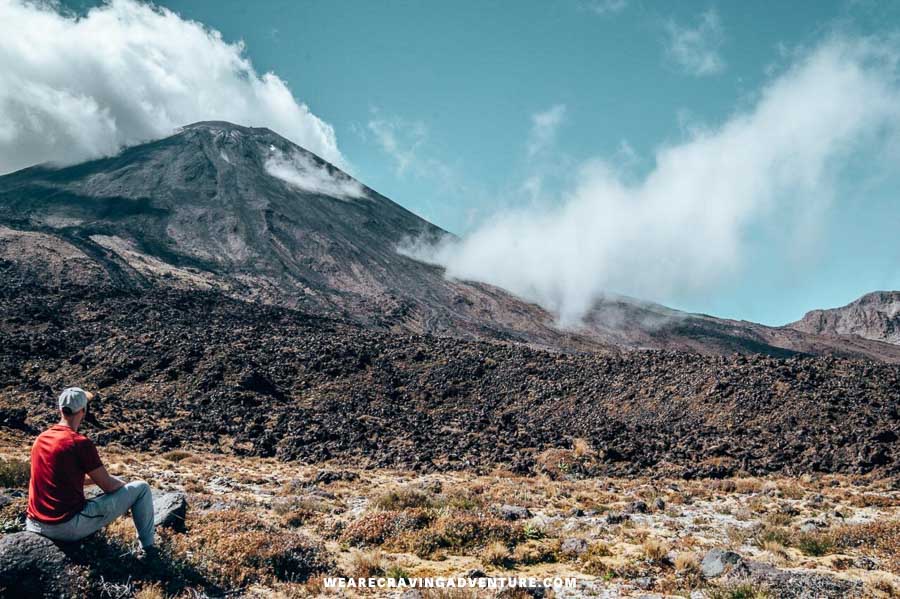
Mt. Ngauruhoe (Mount Doom) is already visible now and if you’re a Lord of the Rings fan you can almost see Sam and Frodo make their way through Mordor. There are many Lord of the Rings filming locations in Tongariro National Park. Don’t get distracted by the sidetrack that takes you to the Mangatepopo Hut, this is part of a bigger, multiple-day circuit through Tongariro National Park. This first part shouldn’t take more than 1,5 hours and ends at the Soda Springs, a small waterfall next to the track.
From this point, the hardest bit of the hike starts. Prepare yourself for a tough, 45-minute long climb that is ominously called the Devil’s Staircase. Pace yourself here because the climb is steep and long, but the views are stunning. On a clear day, you can even see Mount Taranaki in the distance, 150 kilometers away. The hardest part of the climb ends as you pass South Crater, the flooded caldera of a volcanic crater. The walk around South Crater is like walking in a desert. It is a vast and dusty expanse that can look very mystical with the last bits of morning fog rolling over.
Still feeling like you could run up the Devil’s Staircase another time? Then walking the side track up to the top of Mount Ngauruhoe is an awesome way to use that extra energy. Walking to the top to throw the one ring into the fires of Mount Doom and then going back down takes an extra two hours. It is a steep walk going mainly over loose stones and rocks, but the views from the top at 2291 meters heigh are the best in all of Tongariro National Park!

After passing South Crater, the track goes up a bit more over a ridge until you reach the top. The climb isn’t steep though and this part takes about an hour. From here you look straight down into Red Crater and you should have an amazing view on Mt. Ngauruhoe unless it is shrouded if it is a really cloudy day. This is a great point to take a break and have some food. Don’t wait too long though or the masses of people might pass you.
From here the descent starts and you don’t want to get stuck behind large groups of people as you’re going down. The track takes you around Red Crater, and you if you didn’t know any better, you’d think you’re walking on Mars.
From the Red Crater, another sidetrack takes you to the top of Mount Tongariro. The views from the top, and particularly towards Mount Ngauruhoe are incredible, but going up and down adds another 1,5 hours of walking. If you feel fit enough we recommend doing only one of the side tracks, as doing both would take to long. Unless you’ve got the stamina of a trail runner, then by all means!
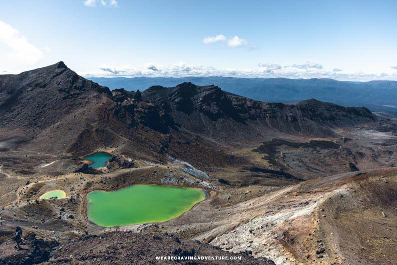
The first part of the descent can be a bit of a scramble. The descent down to Emerald Lakes is very steep and goes over loose gravel-like lava rocks. If you don’t step carefully you can easily start sliding and lose your balance. Take some time to look at and take photos of the Emerald Lakes. Minerals from the surrounding rocks give these lakes their blue-greenish colour and when you add the steam coming from the vents right above it you have yourself an awesome picture opportunity. Then further down you get to the bigger Blue Lake, this lake is sacred to the Māori people. Please don’t sit or eat at its shores as this is considered to be disrespectful.
After Blue Lake, the track climbs a bit again and after about an hour you reach the saddle next to North Crater. This is another beautiful spot for a break that gives sweeping views over the rest of the way down, and Lake Rotoaira and Lake Taupo visible in the distance. Don’t forget to apply sunscreen because the sun is at full strength now and the next part you’ll walk completely in the open.
The last two hours of the hike are all downhill. You zigzag your way down through the grassy mountainside. Don’t try to walk down too quickly because the descent is long and quite straining, especially on the knees. After zigzagging down you enter the forest that provides some very welcome shading, and half an hour later you’ll reach the end of the track at the Ketetahi Car Park. Rest your legs and take the shuttle back to National Park.

Should you hire a guide?
Does all the preparation needed for the hike feel a bit overwhelming, or are you not a 100% confident about doing the Tongariro Alpine Crossing on your own, then we highly recommend to book this guided tour. Your guide will arrange everything for you, including transport, hiking gear and lunch. Before setting off they will fully prepare and equip you to complete the hike, and they will constantly check the weather conditions to keep you safe. They know the track inside out and will make sure that you feel as comfortable as possible and get the most out of the hike.
Booking this guided tour is also great if you want to learn more about the hike and Tongariro National Park, as your guides can tell you all about it. Your guide will also know how to avoid the most crowded parts of the track, which is another bonus.
If you want to hike crossing in between June and October, then booking a guide is a must. Unless you’re a seasoned alpinist, it is not safe to hike the track in winter so you’ll need a qualified professional to guide you. Your guide will know which parts of the track are safe, and they’ll provide you with the necessary equipment like crampons and an ice axe.

What to pack
A big part of preparing for a hike like this is packing the right hiking gear. This is what you should consider packing for the Tongariro Alpine Crossing:
- Day pack – Get one that is comfortable and big enough to carry all that you need for a day hike. A bag with a carrying capacity of 25-30 liters should be enough. We really like this Osprey Daylite Plus.
- Light hiking clothes – Once the sun hits, it can get super hot on the track. Wear clothes that are light and ventilate well, because you’re gonna get sweaty.
- An extra layer – In the morning it can still be quite chilly, so start by wearing an extra layer that you can take off once it gets warmer.
- Sunscreen, sunglasses and a cap – New Zealand’s sun is strong, always wear sun protection, especially when you’re in the mountains.
- Rain Jacket – As mentioned before, the weather conditions can change rapidly. We recommend getting a rain jacket like this The North Face Venture 2 Jacket.
- Hiking shoes – Wearing hiking shoes might seem obvious, but we’ve seen people that tried to hike the Tongariro Alpine Crossing on jandals (the kiwi word for flip flops). We’ve even overheard a guide saying that he once had a lady in his group that was wearing heels. She obviously wasn’t able to complete the hike. The track goes over uneven terrain, rocks, and even slides down on gravel-sized lava stone at some point, so hiking shoes are no unnecesary luxury. Hiking shoes like these Merrell Moab 2 will do just fine.
- Water – Take 3 liters of water per person with you.
- Food – Pack a lunch and some high-energy snacks.
- Camera – You’ll truly regret it if you forget your camera because the views are incredible! Drones are not allowed. Bummer, we know, but completely understandable with this amount of people.
Best Tongariro Crossing Accommodation
We recommend that you stay in National Park. This is the village closest to the start of the track. National Park Village has the most accommodation options in the area, and it is the shuttle service pick-up and return point, making National Park the best place to stay for the Tongariro Alpine Crossing.
PERFECT LOCATION – Pipers Lodge is located in the middle of National Park, conveniently close to the main road. The beds are super comfy, which you’ll love after a day of hiking, and when it gets cold they have a cozy fireplace to warm up next to. Check prices
GREAT VALUE – Plateau Lodge has dorms, private rooms and apartments. A great addition is that they also offer a shuttle service to the Tongariro Alpine Crossing, and they have a hot tub that guest can use to relax their muscles after the hike. Check prices
INCREDIBLE SCENERY – Tongariro Suites offers incredible views on Tongariro National Park. To make things even better they also have a large hot pool to admire the view from. Check prices

Tongariro Northern circuit
Most of the Tongariro Alpine Crossing is actually part of a longer, multiple-day hike called the Tongariro Northern Circuit. This 45 kilometer loop is one of New Zealand’s nine Great Walks and takes three to four days to complete. The circuit starts from Whakapapa Village, and takes you past Mount Tongariro, all around Mount Ngauruhoe, and alongside the incredibly impressive Mount Ruapehu in a circle through the center of Tongariro National Park. DOC operates three huts along the circuit for you to stay in overnight. If you’re interested in walking the Tongariro Northern Circuit, then find more information here.
Tongariro Crossing is worth it
The Tongariro Alpine Crossing is a challenging hike, but absolutely worth it! You’ll be hard-pressed to find a day hike with this much variety and unique landscapes anywhere else in the world. Even if you’re not that into hiking you’ll probably love the Tongariro Crossing because it is just so rewarding. Heck, it might even change your opinion about hiking altogether and turn you into an avid hiker! But don’t just take our word for it, go see it for yourself. We’re sure you won’t regret it!

OMG – I am so marking this down on my bucket list! This is giving me major LOTR vibes! That’s crazy that 50 people get rescued each year – yikes – but good to know ahead of time that it isn’t a walk in the park. The scenery is absolutely gorgeous!
Hi Sarah, for Tom the LOTR vibes were the whole reason why he wanted to do this hike in the first place haha! Don’t worry too much about having t get rescued, the people that get rescued either weren’t cautious and injured themselves or got caught in extreme weather conditions. If you prepare well none of that is likely to happen :).
Wow! This is a great summary of travel tips for Tongariro…I’ve always wanted to go to New Zealand and plan to add this place to the top of my bucket list. Thanks so much for sharing!
Thanks Jess! And that is awesome, you’ll love New Zealand! It is full of unique places and sceneries like the Tongariro Crossing!
I did the Tongariro Crossing many years ago and I still remember how beautiful it was to this day. The views are otherworldly. Thanks for letting me travel down memory lane.
So cool that you already did the Tongariro Crossing, Karen! It is such a memorable experience, right? We actually did it quite a while ago and can still envision the hike as if we did it last week!
What incredible views. This looks amazing. I’m really getting back into hiking and although I think it might be a while before I make it back to New Zealand this looks like one for the list for sure. For how busy it can be, you would never know by your photos. It’s like you’re the only one there.
Thank you Emma! If you’re into hiking, then you’ll certainly love the Tongariro Alpine Crossing, and it shouldn’t even be that hard for you then :). We basically started hiking at first light, so we were able to take most pictures before groups of other people caught up with us.
I love hiking on all the trips that I take! New Zealand is so high on my bucket list. This is a thorough guide and the tips are definitely useful if I ever make it to the island!
Hi Anna, New Zealand is incredible for hiking! The Tongariro Crossing is an amazing day hike, but if you’re serious about hiking you can also have a look at the many multiple-day hikes in New Zealand. There are 9 official multiple-day ‘Great Walks’ and even some hikes that take up to 10 days.